Imagine walking into the small wooden building that serves as the home and office of a tribal community leader in a remote village in Vietnam. One of the last things you might expect to see would be that leader talking to a team of young villagers, with e-tablets in hand, ready to walk their ancestral lands and map GPS coordinates of forests and fields. Yet, in many parts of the world, this sort of scene is no longer uncommon.
As internet-based tools began to take off a decade or so ago, scientists and development practitioners realized that by giving high-tech to rural, remote, or otherwise overlooked communities they could “leapfrog” development. Why build electric lines to roving Maasai groups in the Rift Valley when portable solar power exists? Why manually monitor saffron trade in Afghanistan when cell phone apps could analyze market flows more quickly? And why ask Sumatrans to draw paper maps of their land boundaries, when basic training could help them upload the exact coordinates of their land to the cloud?
Co-benefits to these types of technologies abound. Not only is collecting data electronically typically more accurate and much faster, it is also more permanent. As one example, after the 2010 earthquake destroyed much of Haiti, incidents of gender-based violence rose. But, the local women’s groups that usually addressed this issue had their records destroyed when buildings collapsed. One group worked with these women’s groups to build an online system to store the data, as well as simple mobile apps to help women report incidences where and when they happened.
Another co-benefit is technical training. Those born in remote areas or low income communities of the developed and developing world are far less likely to attend university than urban or suburban dwellers. This enables cycles of poverty in such communities to continue. A growing number of organizations are going a step beyond just using tech, and are also giving people practical, real-world technical training which will help them enter the global economy. Examples include one that teaches women throughout Africa to be tech entrepreneurs, and one that trains aboriginal Australians to map their lands; many more exist.
Yet another co-benefit is improvement to the tech itself. Indigenous or traditional knowledge has fueled many modern inventions, from willow bark extracts creating aspirin, to Inuit histories that help document climate change impacts in the arctic. Realizing the enormous value of this traditional ecological knowledge (TEK) some groups are trying to quickly document and preserve this knowledge, create spaces for traditional knowledge keepers to network, and using this collective wisdom to fine-tune technical environmental conservation approaches.
The last SIG blog post covered the work we’ve been doing with the White Mountain Apache to help them map forest degradation and growth. That work is part of a larger constellation of tech tools that SIG is putting into the hands of local people and environmental practitioners worldwide. The newest of these is Collect Earth Online (CEO), a custom, open-source, satellite image viewing and interpretation system that collects data through Google Earth. CEO, as its’ name implies, is cloud-based, allowing for use anywhere there is an internet connection. This makes it a powerful tool for people in developing regions of the world that have internet, but limited access to computers and high-speed processors.
CEO allows anyone, anywhere to register themselves or their institution and start land cover analyses projects. Once registered, a user can choose what satellite data they’d like to use from default data providers such as DigitalGlobe or by adding in other servers, known as Web Map Services (WMS) that share georeferenced data over the internet. To the non-technical expert this may seem daunting, but the point of CEO is that you don’t need programming know-how to be able to set up your data. In a few simple steps, multiple years of images can be added in so that users can compare land changes like deforestation or shifting cultivation patterns from swidden agriculture.
Once data is specified, a new project can be started. Inventory plots are placed across the landscape either at random, according to a set grid, or uploaded as a shapefile or csv. Different labels are then added to each plot – perhaps you want to analyze land cover type, moisture levels, and density of vegetation cover for your project. Questions about these labels can be added into the analysis options, and each can assigned different colors so that the user can easily see multiple land features. Widgets, such as time series graphs, can be created; these make it easier to interpret land use and cover changes, and flag good versus bad imagery.

Another relatively new SIG tool is the Post Fire Vegetation Monitoring System. This System uses Google Earth Engine to provide users with current and past vegetation cover areas burned by wildfire. It allows users to instantly determine the cover of several vegetation types, including evergreen forests, grasslands, deciduous forests, and barren lands. The cover estimates are made at 30m spatial resolution and segregated to any area of interest, including past burn perimeters, burn severity perimeters, hydrological units (HUCs), or any shape defined by the user.
The system integrates the full Landsat image archive (1984-Present) and provides land managers with near real-time updates on areas that have burned by wildfire. Updates include changes in vegetation cover, vegetation type, and cover of bare soil. A slider on the map allows the user to navigate through time and analyze land cover changes between specific years. Eight different layers (from evergreen forest to barren land to developed land) allow users to pick and choose what sorts of land types they want to include in their analyses.
All of this is available free online, providing land managers with information that may be used to better identify, plan, budget for, and execute post-wildfire rehabilitation projects. These activities might include post-wildfire harvest, reforestation, revegetation, and other erosion control activities. The system is currently programmed to work in Plumas County, California, but will be expanded to include all fire prone areas of the US West.
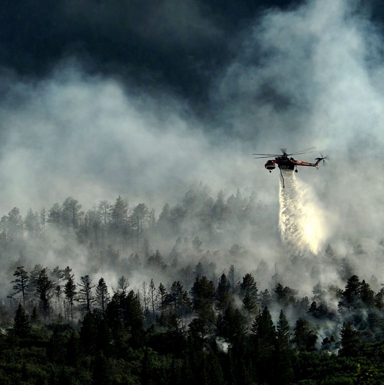
How do you monitor regrowth after a fire like this?
Image by David Mark from Pixabay
While these tools may not yet be in the hands of the hypothetical village chief alluded to in the beginning of this post, they are nonetheless being put into the hands of local-level land managers. CEO in particular has been demonstrated to local government officials in the Mekong, Himalaya and Amazon regions, where SIG and partners are developing more decision support tools through the SERVIR program.
Research shows that when communities manage their own lands they typically use it sustainably and have better local livelihoods. This is because local people know their land intimately and are far better at administering it than a far-off government agency. If they are given the right knowledge and simple tools, they will be able to make even smarter land use decisions. As connectivity improves world over, more people in remote areas will be able to access these tools, reducing the costs and improving the effectiveness of international development. This will give more sovereignty to local people who have long had access to, but not decision-making power over, their small piece of the Earth.