Close
Close
$180 billion USD.
8400 buildings.
1,381,000 acres.
Nearly 8% of the State of California’s GDP.
The numbers produced by wildfires are staggering.
In 2015, the world experienced the strongest El Niño year on record, and forest fires tore through homes, businesses and lives in many parts of the world – one of which was California. That year 150,000 acres burned in the state, costing over USD $1 billion in insurance claims. This past year, 2017, the numbers were even worse and an inglorious new record was set. According to the most recent estimates, which are still coming in, 8400 buildings were destroyed in Northern California’s wine country alone, a total of 1,381,000 acres were burned statewide, and some estimates suggest that the total cost of the fires will be about $180 billion USD, or 8 percent of the states’ GDP.
California is one of several places around the globe that have been impacted by large, high severity fires in recent years. And worse, these catastrophic fires have been becoming more expensive and difficult to control over the last several decades due to fuel (brush, shrubs, tree) accumulation, extensive development in the wildland-urban interface, and shifting precipitation patterns influenced by climate change.
These fires also often occur in or near areas with high population densities, devastating hundreds of thousands of lives through their effects. These effects include loss of life from smoke inhalation, razed homes, shuttered businesses, closed schools, disrupted local economies, and millions of dollars of lost property. And, in a sort of negative feedback loop, these fires also reduce the ability of forests to sequester carbon. Large, high severity fires kill hundreds of thousands of acres of trees that would normally take carbon out of the atmosphere, acting as carbon sinks and natural filters for pollution. High intensity fires can also impact vital soil components, such as mycorrhizae, seedbeds and nutrient-rich humus layers, as well as reduce the water holding capacity of soils. Forest fires therefore worsen the degree to which our climate is changing, in more ways than one.

The ecosystems of California have experienced lightning- and human-caused wildfires for millennia. Prior to 1800, it is estimated that an average of 4,400,000 acres of California would burn per year; many of those fires burned over days to months during the summer and fall. Western dry forests are by nature dependent upon fire; before Europeans settled in or near these forests, fires burned naturally on a multi-annual cycle, keeping fuel loads low, restricting the bulk of wildfires to smaller areas and heat levels, and protecting the older trees and overall forest resilience. But, since the beginning of the 20th century, fire has been excluded from many ecosystems because forest managers were actively suppressing it. Earlier in the 20th century, we thought this was the best way to save lives and property. However, science is now showing us that this practice has now resulted in excess fuel – meaning that there are now intense wildfires in many areas that formerly experienced frequent, but low-severity, fires.
Today, paradoxically, California is faced with the conflicting challenges of restoring the forest structure, by both reintroducing fire into, and keeping wildfire out of, millions of acres of ecosystems. This challenge is exacerbated by myriad factors: forest structure, climate change, development in the wildland-urban interface, the need to protect forest carbon stores, health concerns posed by wildfire emissions, and the potential for landslides in areas that have burned.
In California, SIG was recently working on this challenge in partnership with CALFIRE and the Desert Research Institute (DRI). Together they have developed an updated map of California’s wildfire risk distributions for the California Public Utilities Commission. The SIG team used a weather forecasting model to produce 10 years of weather data for all of California, which was overlaid on a gridded map and calibrated with local historical weather readings from around the state. Using this enormous dataset, the researchers then ran models of over 100 million possible fire ignitions and statistically estimated where the top two percent of the worst fire weather conditions would be. With this info they developed two-kilometer resolution maps showing the areas of greatest fire risk across the state, helping them predict and direct future fire risk mitigation efforts towards where they are most needed.
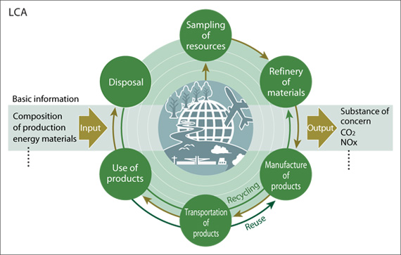
While that work has been completed, the next stage is for SIG to ask – what are the costs vs. benefits of reducing emissions from wildfires in these high-risk areas? And, how can we balance the environments’ ecological needs for fire with the needs to protect human lives and property? SIG is doing this through a Life Cycle Assessment (LCA), a hybrid economic-ecological technique that attempts to monetize and account for all of the economic and social costs and benefits of a project or product, or what economists call “externalities.” In this case, the externalities that SIG is trying to account for are everything from the actual monetary costs of putting out wildfires, to the “costs” of smoke-filled air on the health of area residents, to the “benefits” of usable open space on residents’ well-being. LCAs are notoriously difficult to perform, due to the extremely complex nature of the environment and the systems within it.

“There has been so much LCA-relevant research coming out lately on the benefits of reintroducing more natural wildfire behaviour from an ecological, climate, and socio-economic perspective, but it has been scattered across many different scientific disciplines. We think we are at the point now where we can merge these insights into one science-based framework that accounts for all the benefits,” says Dr. Thomas Buchholz, who leads this effort on behalf of SIG.
Once the best areas for various fire measures are determined, and the benefits of fire mitigation actions are calculated, this LCA framework will enable landscape managers to apply for carbon credits through the American Carbon Registry. In parallel, SIG is helping high-risk communities design and implement fire protection plans, including components on how to effectively reduce fuel, how to make safe zones around homes, how to plan evacuation routes, and how to push all of these initiatives forward with local officials to get them implemented – lessons which can replicated worldwide.
In California, wildfires are part of the ecosystem, though today in a state with over 40,000,000 residents, large, high severity fires can impact the health of peoples, the economic welfare of their communities, and the resilience of their communities. And, as climate change progresses and causes ever-longer dry seasons in many parts of the world, these fires are not going to lessen. This is why it’s important that communities the world over work quickly to address the underlying causes of fires, whether it be inadequate spatial planning, past ecological practices, or inadequate mitigation measures. Conducting fuel treatments to moderate the impacts of wildfires and to restore forests in California is a complex and expensive undertaking involving government agencies, communities, and individual landowners. Understanding how to most effectively conduct this work is essential for conserving the forests of California for future generations.