Forest & Agriculture Management & Natural Hazards

Case Study

Modeling Fire Resiliency from Landscape-scale Fuel Treatments

Experiments with Different Variables to Understand Treatment Prioritization

How can land managers best prioritize landscape scale forest fuel treatments to increase resiliency to wildfires?

Consulting with American Forest Foundation, scientists at SIG evaluated the effectiveness of different proposed landscape-scale fuels treatments by conducting a sensitivity analysis on the level of treatment and the dispersion (spatial arrangement) of those treatments across public and private lands. We used automated workflows for assigning treatment locations, updating fuel layers to reflect that treatment, and running a probabilistic wildfire model to evaluate treatment effectiveness at the landscape scale.

How to Make the Most of Limited Resources?

In fire prone areas like the American West, forest managers often utilize treatments like thinning, prescribed fire, and mastication to reduce wildfire risk. These interventions reduce fuel loads, interrupt fuel continuity, and create fuel breaks to facilitate firefighting. Treatments can take place over a range of spatial scales, ranging from small private parcels to vast public lands. Treatment planning often requires resource managers to design treatment plans that maximize the impacts of treatments via treatment intensity and spatial arrangement.
The Sonora fireshed study area
The Sonora fireshed study area. Fire behavior results were summarized for all cells within the study area
Fuel treatment intensity

What Treatments Make a Difference Without Prioritization?

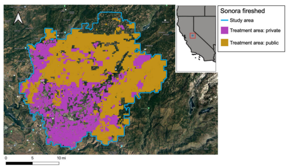
In order to support a program aimed at reducing fire risk on private lands, American Forest Foundation was interested in evaluating the level of treatment needed to reduce fire risk if treatments could not be prioritized according to traditional methods. This reflects the goal of their program to fund the owners of smaller private parcels to do fuels reduction treatments, resulting in an extensive but non-contiguous matrix of treatment areas across the landscape.

Spatial Informatics Group developed a methodology to evaluate the effectiveness of wildfire risk reduction treatments across a range of scenarios of differing treatment intensity, size, and spatial distribution. The central objective was to determine what treatments would be required to achieve fire risk reduction goals in the absence of prioritization.

On the Ground and in the Cloud

SIG’s scientists used the 425-square-mile Sonora fireshed in California’s central Sierra Nevada as a case study. Within the study area, we selected treatment areas based on ownership and vegetation types. We tested the effects of three variables on fire behavior: treatment intensity, treatment size, and land ownership type.

We developed a workflow in Google Earth Engine to model treatments over 52 scenarios leveraging data and models from the National Land Cover Database, USDA Forest Service weather data, LANDFIRE, Fire Family Plus, and GridFire.

Modeling Fire Resiliency
increased treatment intensity

Any Treatments are Beneficial

We found that, regardless of treatment scenario, increased treatment intensity consistently moderates fire behavior metrics. This suggests that treatment is beneficial even if it is not part of a prioritization plan. Rather, increased treatments of any kind consistently reduced modeled fire behavior across the landscape, in both treated and untreated places.