Under international climate change agreements, countries must estimate greenhouse gas emissions related to deforestation and forest degradation.
In cases of deforestation—when trees are cut and replaced by annual crops, for instance—the change in land cover is clearly visible. Forest degradation, by contrast, is more subtle. Trees are lost but the land remains forested and often recovers quickly—making the changes hard to detect.
New research, published in the journal Remote Sensing, identifies ways to improve the collection of information about forest degradation. The work was a collaboration between Nepal’s Forest Research and Training Centre, Spatial Informatics Group–Natural Assets Laboratory (SIG-NAL), and other partners.
The paper, titled “Lessons Learned While Implementing a Time-Series Approach to Forest Canopy Disturbance Detection in Nepal,” was written by lead author Raja Ram Aryal of Nepal’s Ministry of Forests and Environment, Crystal Wespestad of SIG-NAL, and other colleagues. The research was facilitated through the US Government SilvaCarbon program.
By relying on Google Earth Engine and an algorithm known as Continuous Degradation Detection (CODED)—developed by Eric Bullock, another author of the paper—the researchers were able to quantify even relatively minor instances of forest degradation, and to demonstrate that degradation is a major source of greenhouse gases emissions.
The research showed that assessing degradation is crucial to making accurate estimates of forest-related carbon emissions.
And because the research used freely available, cloud-based tools, the methods developed here have the potential to help other countries use remote sensing to accurately monitor their forests in accordance with international climate change agreements.
“This work could easily serve as a model for other developing countries working to establish reliable forest monitoring methods using remote sensing,” the authors write.
“Assessment of forest degradation in Nepal, which is required as activity data for the REDD+ implementation phase, is a great challenge,” Aryal said. “This research highlights the importance of customization of already-tested algorithms for specific locations with the help of local knowledge and experience of real field scenarios.”
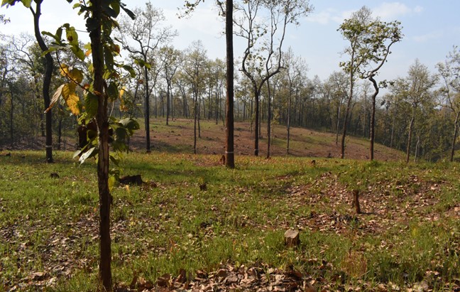
Selective logging in a scientific forest management area in Nepal. Photo courtesy of Bishnu Prasad Dhakal of the Forest Research and Training Centre.
Countries in the Carbon Fund program must report estimates of changes in forest emissions and carbon stocks. Given the vast areas that must be monitored, accurate assessments generally depend on satellite-based remote sensing imagery.
As technology has improved, measuring degradation with remote sensing has become more possible, but it remains challenging.
Degradation can result from fuel wood collection, small-scale timber harvesting, insect damage to trees, and small fires, and forests often recover from such damage within a few years. Detecting such events requires access to imagery collected with relatively high frequency.
In addition, degradation often affects a relatively small area, which means that detecting such an event requires high-resolution imagery.
Freely available satellite imagery can now meet these needs. For example, data from the NASA/USGS Landsat program provides observations every 8–16 days at a resolution of 30 meters—allowing for detection of even relatively short-lived degradation events. Landsat data is integrated into Google Earth Engine, an open-source cloud-computing platform freely available to all.
As these resources become available, however, they must be tested to assess their usability in applied settings. That was the goal of the new paper.
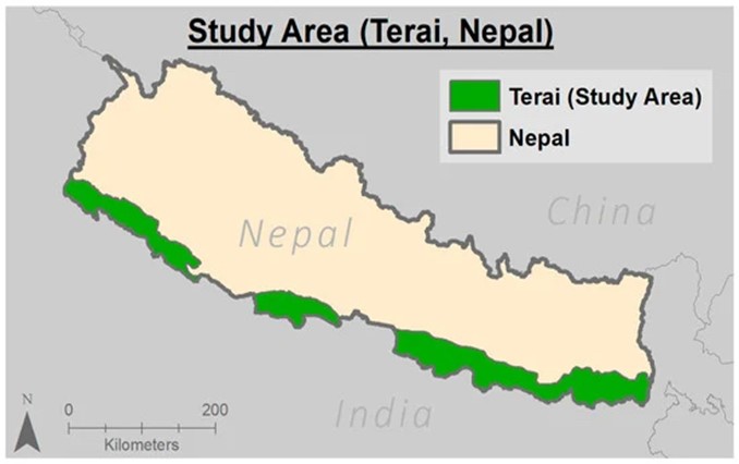
For the study, the researchers focused on the Terai region, which makes up about 14% of Nepal’s geographic area. The region contains a great amount of forest biodiversity, varied types of forest management practices, and a disproportionately large amount of forest degradation activities.
The researchers used the CODED algorithm within Google Earth Engine. CODED evaluates a time series of the Normalized Degradation Fraction Index (NDFI) to monitor forest canopy disturbances. NDFI expresses what portion of a plot of land is covered by green vegetation as opposed to bare soil or non-photosynthetic (i.e., dead or dormant) vegetation. The algorithm compares imagery from the same area at different points in time; if the later images show more bare ground or dead vegetation than the earlier, that serves as evidence of forest degradation.
A key benefit of using CODED with Landsat data is that it has the capacity to capture small-scale, short-term degradation events while reducing false positives that can arise from vegetation that is simply dormant during cold seasons rather than dead.
CODED allows multiple parameters to be adjusted to determine how sensitive the algorithm is in detecting forest degradation. The researchers adopted an iterative approach, adjusting and testing these parameters to find the combination that most accurately captured forest degradation in the study region. It took the team 11 iterations to establish an acceptable set of parameters.
The authors write, “We focused much of our attention on testing parameters within the CODED algorithm—first to improve the accuracy and precision of this analysis, but also to contribute to the literature a more thorough understanding of the relative implications of each parameter adjustment.”
The local knowledge of lead author Raja Ram Aryal proved invaluable. Using Collect Earth Online (CEO)—a free, open-source, web-based tool that facilitates data collection—he compiled training data that allowed the CODED algorithm to distinguish between deforestation and degradation.
Researchers also had access to local information regarding areas that were known to have experienced degradation. They used this on-the-ground information to perform qualitative checks on the performance of each map produced by CODED.
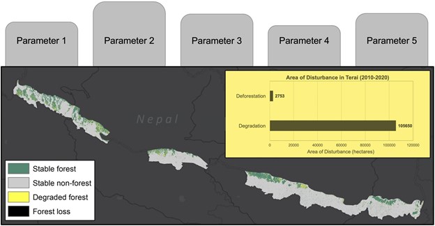
Researchers found that in the study region, far more land was affected by degradation than by deforestation—105,650 hectares vs. 2,753 hectares—during the period 2010–2020. The model created by the team provided area estimates of forest degradation and deforestation with an overall accuracy of 91.7%.
The results demonstrate that CODED can be useful in detecting forest degradation, which is often small-scale and short-lived but nonetheless accounts for a large portion of forest-related emissions.
Given that the Terai is the most diverse and challenging region to classify in Nepal, researchers expect that the model will achieve similar results when applied to the entire country.
The research should enable Nepal to reduce the uncertainty surrounding its estimates of greenhouse gas emissions, which would allow higher payments from the Carbon Fund for its reductions in forest-related emissions.
Even more important, the research provided a guide to other countries interested in using CODED’s free, easy-to-use interface for similar monitoring efforts.
The researchers document their iterative approach in detail and highlight the implications of changing each parameter within a real-world context, because other countries will need to work through a similar process to tune the CODED algorithm’s parameters to their specific ecological contexts.
The authors write that the research offers “a realistic approach for practitioners, detailing an achievable methodology that results in an acceptable level of accuracy for applied uses.”
Although the process is complex, the approach should have wide appeal, allowing countries to manage their forests and unlock result-based payments through emissions reduction programs.
“We approached this project through the lense of a realistic practitioner performing assessments for the REDD+ program,” Wespestad explained. “Our method for tuning CODED to be useful in a specific study area is easily repeatable. In this manuscript we described our methods, but also all the details we learned about the parameters, the algorithm, and degradation in an applied context that we know would be helpful for practitioners beginning this process themselves.”
“This is a milestone approach for generating country-specific forest degradation activity data for the REDD+ program,” Aryal added. “This will help support the measurement, reporting, and verification (MRV) process in Nepal, and it will also help demonstrate how forest degradation impacts climate change.”